What is Geophysics?
Geophysics /dʒiːoʊfɪzɪks/ is the physics of the Earth and its environment in space; also the study of the Earth using quantitative physical methods. The term geophysics sometimes refers only to the geological applications: Earth’s shape; its gravitational and magnetic fields; its internal structure and composition; its dynamics and their surface expression in plate tectonics, the generation of magmas, volcanism and rock formation. However, modern geophysics organizations use a broader definition that includes the hydrological cycle including snow and ice; fluid dynamics of the oceans and the atmosphere; electricity and magnetism in the ionosphere and magnetosphere and solar-terrestrial relations; and analogous problems associated with the Moon and other planets.
Although geophysics was only recognized as a separate discipline in the 19th century, its origins go back to ancient history. The first magnetic compasses date back to the fourth century BC and the first seismoscope was built in 132 BC. Geophysical methods were developed for navigation; Isaac Newton applied his theory of mechanics to the tides and the precession of the equinox; and instruments were developed to measure the Earth’s shape, density and gravity field, as well as the components of the water cycle. In the 20th century, geophysical methods were developed for remote exploration of the solid Earth and the ocean, and geophysics played an essential role in the development of the theory of plate tectonics.
Geophysics is applied to societal needs, such as mineral resources, mitigation of natural hazards and environmental protection. Geophysical survey data are used to analyze potential petroleum reservoirs and mineral deposits, locate groundwater, find archaeological relics, determine the thickness of glaciers and soils, and assess sites for environmental remediation.
Geophysics is a highly interdisciplinary subject and geophysicists contribute to every area of the Earth sciences. To provide a clearer idea of what constitutes geophysics, this section describes phenomena that are studied in physics and how they relate to the Earth and its surroundings.
Gravity:
The gravitational pull of the Moon and Sun give rise to two high tides and two low tides every lunar day, or every 24 hours and 50 minutes. Therefore, there is a gap of 12 hours and 25 minutes between every high tide and between every low tide. Gravitational forces make rocks press down on deeper rocks, increasing their density as the depth increases.
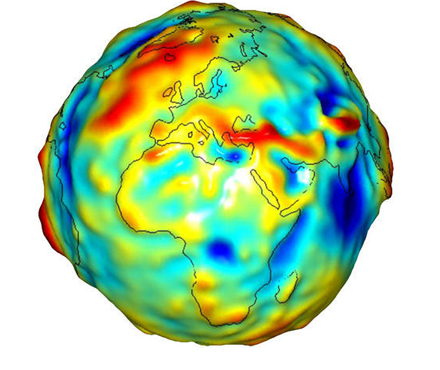
Measurements of gravitational acceleration and gravitational potential at the Earth’s surface and above it can be used to look for mineral deposits (see gravity anomaly and gravimetry). The surface gravitational field provides information on the dynamics of tectonic plates. The geopotential surface called the geoid is one definition of the shape of the Earth. The geoid would be the global mean sea level if the oceans were in equilibrium and could be extended through the continents (such as with very narrow canals).
Heat Flow:
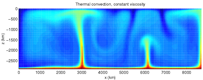
The Earth is cooling, and the resulting heat flow generates the Earth’s magnetic field through the geodynamo and plate tectonics through mantle convection. The main sources of heat are the primordial heat and radioactivity, although there are also contributions from phase transitions. Heat is mostly carried to the surface by thermal convection, although there are two thermal boundary layers – the core-mantle boundary and the lithosphere – in which heat is transported by conduction. Some heat is carried up from the bottom of the mantle by mantle plumes. The heat flow at the Earth’s surface is about 4.2 × 10¹³ W, and it is a potential source of geothermal energy.
Seismology:
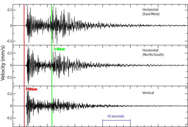
Seismic waves are vibrations that travel through the Earth’s interior or along its surface. The entire Earth can also oscillate in forms that are called normal modes. Ground motions from waves or normal modes are measured using seismographs. If the waves come from a localized source such as an earthquake or explosion, measurements at more than one location can be used to locate the source. The locations of earthquakes provide information on plate tectonics and mantle convection.
Measurements of seismic waves are a source of information on the region that the waves travel through. If the density or composition of the rock changes suddenly, some of the waves are reflected. Reflections can provide information on near-surface structure. Changes in the travel direction, called refraction, can be used to infer the deep structure of the Earth.
Earthquakes pose a risk to humans. Understanding their mechanisms, which depend on the type of earthquake (e.g., intraplate or deep focus), can lead to better estimates of earthquake risk and improvements in earthquake engineering.
Electricity:
Although we mainly notice electricity during thunderstorms, there is always a downward electric field near the surface that averages 120 V m-1. Relative to the solid Earth, the atmosphere has a net positive charge due to bombardment by cosmic rays. A current of about 1800 A flows in the global circuit. It flows downward from the ionosphere over most of the Earth and back upwards through thunderstorms. The flow is manifested by lightning below the clouds and sprites above.
A variety of electric methods are used in geophysical survey. Some measure spontaneous potential, a potential that arises in the ground because of man-made or natural disturbances. Telluric currents flow in Earth and the oceans. They have two causes: electromagnetic induction by the time-varying, external-origin geomagnetic field and motion of conducting bodies (such as seawater) across the Earth’s permanent magnetic field. The distribution of telluric current density can be used to detect variations in electrical resistivity of underground structures. Geophysicists can also provide the electric current themselves (see induced polarization and electrical resistivity tomography).
Electromagnetic waves
Electromagnetic waves occur in the ionosphere and magnetosphere as well as the Earth’s outer core. Dawn chorus is believed to be caused by high-energy electrons that get caught in the Van Allen radiation belt. Whistlers are produced by lightning strikes. Hiss may be generated by both. Electromagnetic waves may also be generated by earthquakes (see seismo-electromagnetics).
In the Earth’s outer core, electric currents in the highly conductive liquid iron create magnetic fields by electromagnetic induction (see geodynamo). Alfvén waves are magnetohydrodynamic waves in the magnetosphere or the Earth’s core. In the core, they probably have little observable effect on the geomagnetic field, but slower waves such as magnetic Rossby waves may be one source of geomagnetic secular variation. Electromagnetic methods that are used for geophysical survey include transient electromagnetics and magnetotellurics.
Magnetism
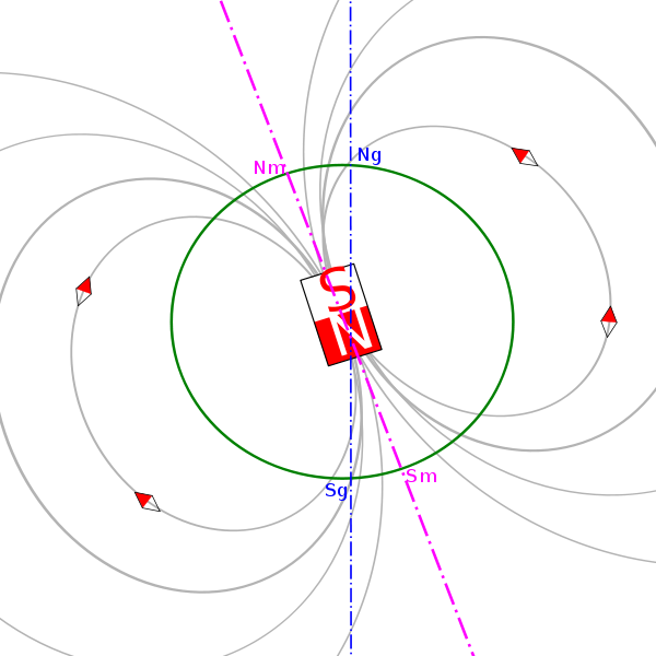
The Earth’s magnetic field protects the Earth from the deadly solar wind and has long been used for navigation. It originates in the fluid motions of the Earth’s outer core (see geodynamo). The magnetic field in the upper atmosphere gives rise to the auroras. The Earth’s field is roughly like a tilted dipole, but it changes over time (a phenomenon called geomagnetic secular variation). Mostly the geomagnetic pole stays near the geographic pole, but at random intervals averaging a million years or so, the polarity of the Earth’s field reverses. These geomagnetic reversals are recorded in rocks (see natural remanent magnetization) and their signature can be seen as parallel linear magnetic anomaly stripes on the seafloor. These stripes provide quantitative information on seafloor spreading, a part of plate tectonics. They are the basis of magnetostratigraphy, which correlates magnetic reversals with other stratigraphies to construct geologic time scales. In addition, the magnetization in rocks can be used to measure the motion of continents.
Radioactivity
Radioactive decay accounts for about 80% of the Earth’s internal heat, powering the geodynamo and plate tectonics. The main heat-producing isotopes are potassium-40, uranium-238, uranium-235, and thorium-232. Radioactive elements are used for radiometric dating, the primary method for establishing an absolute time scale in geochronology. Unstable isotopes decay at predictable rates, and the decay rates of different isotopes cover several orders of magnitude, so radioactive decay can be used to accurately date both recent events and events in past geologic eras.
Fluid Dynamics
Fluid motions occur in the magnetosphere, atmosphere, ocean, mantle and core. Even the mantle, though it has an enormous viscosity, flows like a fluid over long time intervals (see geodynamics). This flow is reflected in phenomena such as isostasy, post-glacial rebound and mantle plumes. The mantle flow drives plate tectonics and the flow in the Earth’s core drives the geodynamo.
Geophysical fluid dynamics is a primary tool in physical oceanography and meteorology. The rotation of the Earth has profound effects on the Earth’s fluid dynamics, often due to the Coriolis effect. In the atmosphere it gives rise to large-scale patterns like Rossby waves and determines the basic circulation patterns of storms. In the ocean they drive large-scale circulation patterns as well as Kelvin waves and Ekman spirals at the ocean surface. In the Earth’s core, the circulation of the molten iron is structured by Taylor columns.
Mineral Physics
The physical properties of minerals must be understood to infer the composition of the Earth’s interior from seismology, the geothermal gradient and other sources of information. Mineral physicists study the elastic properties of minerals; their high-pressure phase diagrams, melting points and equations of state at high pressure; and the rheological properties of rocks, or their ability to flow. Deformation of rocks by creep make flow possible, although over short times the rocks are brittle. The viscosity of rocks is affected by temperature and pressure, and in turn determines the rates at which tectonic plates move (see geodynamics).
Water is a very complex substance and its unique properties are essential for life. Its physical properties shape the hydrosphere and are an essential part of the water cycle and climate. Its thermodynamic properties determine evaporation and the thermal gradient in the atmosphere. The many types of precipitation involve a complex mixture of processes such as coalescence, supercooling and supersaturation. Some of the precipitated water becomes groundwater, and groundwater flow includes phenomena such as percolation, while the conductivity of water makes electrical and electromagnetic methods useful for tracking groundwater flow. Physical properties of water such as salinity have a large effect on its motion in the oceans. The many phases of ice form the cryosphere and come in forms like ice sheets, glaciers, sea ice, freshwater ice, snow, and frozen ground (or permafrost).